Mobile Blackspot Programme rollout schedule announced

Mobile Black Spot Programme – Funded Base Stations

Nineteen mobile base stations have already been completed and the first six-month rollout schedule lists the new or upgraded base stations to be built in Queensland, New South Wales, Victoria, Western Australia, South Australia and Tasmania by the first half of this year.

The full rollout of the 499 new or upgraded base stations will be completed over the next three years and the rollout schedule will be updated half-yearly with the most up-to-date information from mobile network operators of the new base stations scheduled to be built.

Announced on 17th of February 2016

Details of recent and by June 2016 Mobile Black spot remediation roll-out are listed here and Includes Araluen but sadly not Tomboye yet. Tomboye is however already nominated / Funded and should be in place within three Years; See below the details of local Towers.

Mobile Black Spot Programme – Funded Base Stations

Araluen

Location Name    Araluen
MBSP identifier    MBSP-NSW-003
Applicant    Telstra
State    NSW
Electorate    Eden-Monaro
Local Government Area    Palerang
Regional Development Australia region    Southern Inland
Latitude    -35.6507
Longitude    149.8122
MNO identifier    TLS_015_NSW_0032

Mayfield

Location Name    Mayfield
MBSP identifier    MBSP-NSW-083
Applicant    Telstra
State    NSW
Electorate    Hume
Local Government Area    Goulburn Mulwaree
Regional Development Australia region    Southern Inland
Latitude    -35.1085
Longitude    149.7924
MNO identifier    TLS_084_NSW_0214

Nerriga

Location Name    Nerriga
MBSP identifier    MBSP-NSW-097
Applicant    Telstra
State    NSW
Electorate    Eden-Monaro
Local Government Area    Palerang
Regional Development Australia region    Southern Inland
Latitude    -35.1113249
Longitude    150.0900691
MNO identifier    TLS_433_NSW_1162

Tomboye

Location Name    Tomboye
MBSP identifier    MBSP-NSW-125
Applicant    Telstra
State    NSW
Electorate    Eden-Monaro
Local Government Area    Palerang
Regional Development Australia region    Southern Inland
Latitude    -35.25447909
Longitude    149.9630478
MNO identifier    TLS_563_NSW_1567

Windellama

Location Name    Windellama
MBSP identifier    MBSP-NSW-139
Applicant    Telstra
State    NSW
Electorate    Hume
Local Government Area    Goulburn Mulwaree
Regional Development Australia region    Southern Inland
Latitude    -35.0224131
Longitude    149.8741118
MNO identifier    TLS_632_NSW_1736

For More details

Posted in News, Services, Telecommunications | Leave a comment

Be careful Crossing Rivers after rain – Video

See this video shared in facebook than demonstrates the power of a creek when rising.


Posted in Uncategorized | Leave a comment

Local Facebook presence

Do check them out and network with our Community


Posted in Uncategorized | Leave a comment

Tomboye Community Aggregator now operating

Tomboye Community Agregator is a website that will bring posts from all Tomboye related websites together. News and Information from Tomboye NSW Australia community including this site, landcare and residents websites.

Strengthening local community.

Posted in Community, Tomboye Website News | Leave a comment

Tomboye.net your home on the internet

We now have some more members obtaining a website and Email addresses @tomboye.net, both for there personal, and business use and soon even an art project.

Watch this space

Posted in Community, Tomboye Website News | Leave a comment

Trespass in the Tomboye Area ?

To all residents and land owners in the Tomboye Area. There are reports of Trespass in the Tomboye Area. the indication of this is the cutting sections of mesh fences to permit access through fences. The wire is then returned to its original position so that it is not obvious from a distance.

If you observe such indicators, or have further information please let Tony know by email so he can collate the information and it can be presented as needed to the Authorities.


Posted in News | Leave a comment

Ooranook Homestead

Ooranook – Welcome Reef Dam : About New South Wales
http://about.nsw.gov.au/collections/doc/ooranook-welcome-reef-dam/

The Ooranook Homestead is a highly significant component of the overall Tallaganda rural cultural landscape. Based on a preliminary site analysis, several elements were considered to contribute to this high level of landscape significance. The Homestead building itself is associated with the early settlement and rural usage of the district surrounding Stewarts Crossing, and served as the focus of property life.

Posted in History | Leave a comment

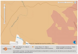
New Next G Coverage Map for Tomboye Area

This is NextG only not GSM

I wonder how close this is to the real world ?, Since Christmas my Telstra reception has worsened for my mobile near the shack but not on the hills where it is fine.

Source

Posted in Uncategorized | Leave a comment

Atlas of Living Australia has Tomboye Records

Visit the Tomboye Landcare site and see this post or from the Menu “More Information” select Local Species recorded to see local observations of animals. Links are available to details and photos of each species.

Can we add to this fantastic resource ?

Posted in Landcare, The Environment | Leave a comment

Visit our Landcare site for a little fun

My Blackberry then look around the site.

Posted in Landcare, News | Leave a comment